Showing posts with label Eastern Oregon. Show all posts

Monday, March 3, 2014

Lasting Legacy of the CCC


At the Forest History Center on State Street in Salem there stands a life-size statue of a hunky, shirtless, young man leaning on a shovel. 
CCC Worker Statue
He is posed in front of a wooden, green building with a pair of gables and twin dormer windows. Their connection is a federal program initiated by Franklin D. Roosevelt shortly after his inauguration to provide jobs for the nation’s growing number of unemployed young men.

Known as the Civilian Conservation Corps, or CCC, it operated between 1933 and 1942, and was one of the most successful and popular New Deal programs.  Oregon was an active participant with over 60 camps scattered around the state. The men built roads, bridges, trails, campgrounds, fought forest fires, and planted trees. In exchange for their labor, they received education, job training, food and shelter (three hots and a cot) and the grand sum of $30 a month. They could keep $5 with the other $25 sent home to their families.  Even though eighty years have passed and many CCC efforts are long gone, about one-third of the permanent projects in Oregon remain and can still be enjoyed in forests and parks around the state.
Forest History Center, Salem

The Forest History Center is a good place to begin. The building was constructed by the CCC in 1936 to house their headquarters, and was moved to its present location from the east side of Mill Creek in 2001. Today, a section of the museum is dedicated to the CCC program and features camp photos, a wall map with site locations, and miscellaneous memorabilia donated by alumni. The CCC Worker Memorial Statue in front was dedicated in 2002.

Silver Falls Lodge
One of the program’s permanent projects is a short distance east of Salem at Silver Falls State Park. The CCC was responsible for constructing much of the infrastructure seen in the South Falls Day Use Area including rocks walls, bridges, stairs and the rustic South Falls Lodge. The lodge and surrounding ten acres are listed in the National Register of Historic Places. In addition, the CCC developed the park’s popular Trail of the Ten Falls.

West Shelter, Cape Perpetua
The Oregon Coast hosted several CCC camps, and remnants of Camp Cape Creek remain visible on the site of the Cape Perpetua Visitor Center, two miles south of Yachats.  Workers here built the campground and network of trails, but their most noted accomplishment was the West Shelter observation point at the top of the headland. Built of rocks, this sturdy structure has survived years of Pacific storms and even served as a coastal watch station during World War II.  Today’s visitors are more interested in spotting migrating whales than enemy boats or planes.

Mt. Hood National Forest, east of Portland, also saw many CCC projects. Camp Zigzag on Highway 26, was the longest running camp in the Northwest, and its workers built the Zigzag Ranger Station on the south side of the road. This compound consisting of various outbuildings is constructed in the Cascadian Rustic style using natural materials such as wood shingles, weatherboard, and native stone.  A similar, but more off-the-beaten-path ranger station can be visited on Forest Road 42, about 20 miles southeast of Government Camp. Here, at the Clackamas Lake Historic Ranger Station, are eleven buildings including a small visitor center. The ranger’s residence was built by the CCC in 1933 and is available for rental during the summer months.

Mt. Hood’s Timberline Lodge, probably the best known Depression-era project in Oregon, was constructed by the WPA, but the CCC worked on the lodge’s terracing, stonework, and landscaping. They built the Timberline Trail encircling Mt. Hood and worked on a variety of other projects in the area including Cloud Cap Inn and several campgrounds.

Malheur Nat'l Wildlife Visitor Center
In other parts of the state you’ll find evidence of the CCC at Crater Lake’s Rim Road and Rim Village, the rock work at Oregon Cave’s Chateau, the Visitor Center and Museum at the Malheur Wildlife Refuge, Jessie Honeymoon State Park near Florence, and the Dee Wright Observatory at the summit of McKenzie Pass.

The CCC program lasted only nine years.  By 1942, the country was gearing up for WWII and young men were leaving to join the army.  However, their hard work through those difficult Depression years left a significant contribution and lasting legacy to Oregon’s public lands.


Friday, August 10, 2012

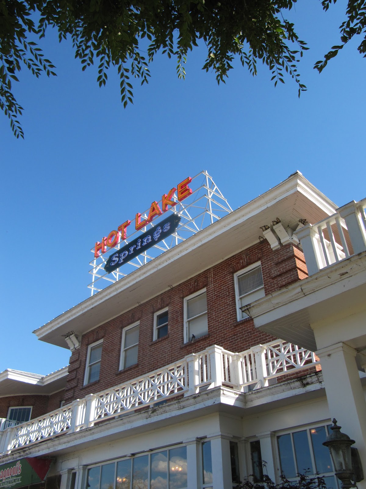
Hot Times at Hot Lake Springs

Hot Lake Springs
During the 1910s and 1920s it was the hottest spot in Oregon. Three daily trains from Portland brought hundreds of guests to “take the waters” at the Hot Lake Hotel and Sanitorium, a little southeast of La Grande. They would bathe in the hot mineral waters, soak in sulfuric baths, and wallow in mud from the lake’s sediment in an attempt to cure a variety of ills from rheumatism to syphilis.
Of course, it had always been a hot spot thanks to the 208-degree water that bubbles out of the ground creating a steaming, sulfurous lake. Native tribes knew about the water’s healing powers and considered the place holy ground. The first whites to enjoy the lake were fur trappers returning from Fort Astoria in 1812; later on, it was a welcome stopover for immigrants traveling the Oregon Trail.
In the 1860s, a number of wooden structures were built around the lake and, in 1908, a three-story brick hotel with hospital was added. The charismatic Dr. William Phy developed it into a state-of-the-art medical facility with labs, operating rooms, teaching hospital, and an innovative x-ray machine that seems more like a prop from a sci-fi horror film. It was often referred to as the Mayo Clinic of the West and attracted patients and spa seekers from all over the world.
Bathhouse and lake
In 1934, a fire destroyed the large wooden structure.  By then, Dr. Phy had died from pneumonia, the railroad was rerouted, the new highway bypassed the property, and the country had plunged into an economic depression. During World War II, it served as a training facility for nurses and later as a nursing home. Over time, the building fell into disrepair.  Vandals had broken all but two of the 360 windows, and looted the fixtures and marble tiles. Holes in the roof allowed water to damage floors and walls. Several attempts to save the structure failed and the future seemed grim for this piece of Oregon history.
At the same time, David Manuel was establishing a reputation as a renowned bronze sculptor and transforming the little town of Joseph in nearby Wallowa County into a noted art community.  He and his wife, Lee, frequently drove by the Hot Lake Hotel observing its sorry condition but also envisioning the property’s potential as a major tourist destination. In 2003 they sold off their interests in Joseph and bought the place. While the old hotel’s foundations were still sound, everything else was a mess and it would be a daunting and expensive task to restore it. Eight years, a lot of hard work, and over $12 million dollars later, Hot Lake Springs was back in business with its grand re-opening in August, 2011.
One of the B & B rooms
Twenty-two of the former hotel rooms have been transformed into a bed and breakfast. Since the rooms were decorated and furnished by local donors, no two are alike. There is a charming breakfast nook and an Italian restaurant on the premise as well as a theater, full service spa, indoor and outdoor soaking tubs. The Manuels also moved their bronze foundry to the site and guests can take a tour and watch a video describing the lost-wax casting process. Many of his pieces, mostly of wildlife and Western themes, are displayed in an on-premise art gallery. Manuel has maintained a long interest in Western art and history, especially Native American history, and a small museum contains an outstanding display of artifacts he has collected over the years.
Outside, there is an antique vehicle display, honor garden, and life-size bronze statue of “The Promised Land,” the same one that occupies Chapman Square in downtown Portland.
The Promised Land
To see more photos and artifacts from Hot Lake’s heyday, take a short drive south to the town of Union with its wonderful county history museum.  The display of medical apparatus and equipment used at the hospital will make you grateful to be living in the 21st century.
To make reservations or view the various rooms online, visit their website at www.hotlakesprings.com.  It is not necessary to be an overnight guest to enjoy the property and tour tickets are available at $10 for adults. This includes the history museum, bronze foundry (tours at 10:00 am and 2:00pm Monday through Saturday) and access to the grounds and indoor facilities.

Saturday, April 14, 2012

Rattlesnake Grade: A Road to Remember

Oregon Highway 3 on its descent to the Grande Ronde River
On the map, Oregon Highway 3 and its continuation, Washington Highway 129, appear to be a direct shot across the upper right-hand corner of the state, connecting Enterprise, Ore. and Clarkston, Wash.  However, the reality of this road is quite different. Why else would the American Motorcycle Association designate it as one of the top 15 motorcycle rides in America? The 80-mile trip offers an enormous variety of scenery from snow-capped peaks, expansive canyons, pine forests, wide open wheat fields, a narrow river valley, ghost town, and enough twists and turns and plunging drop-offs to make a person dizzy. Fortunately, there is very little traffic.

Joseph Canyon Overlook
Traveling from south to north, the drive begins in Enterprise, the county seat of Wallowa County and, more important, home to the last gas stations for the next 65 miles. The road heads north through rolling prairie and ranch land with spectacular views of the Wallowa Mountains receding in the rearview mirror. Elevation gain transforms the scenery to pine forests, and around 30 miles from Enterprise is the Joseph Canyon Overlook. From here, the view spreads out forever across a network of steep canyons. The Nez Perce called the area Saqanma, meaning long, rough canyon, and made their winter camp here at the confluence of Joseph Creek and the Grande Ronde River in the protected canyon’s bottom.

To savor this remarkable panorama, continue a few miles north to the Rim Rock Inn, a restaurant offering indoor and outdoor dining with a million dollar view. Who would expect to find a turkey panini sandwich with sun-dried tomatoes here in the absolute middle of nowhere! A former stagecoach stop, the inn now has four tepees available for rent for adventurous types wanting to spend the night right on the canyon edge.
Flora Methodist Church

Beyond the inn is a road turning west marked “Flora” and well worth the six mile, roundtrip detour to this once thriving farming and ranch community.  Platted in 1897, the town was named for the daughter of the first postmaster and grew to a population of 320 by 1910 with a bank, general store, and newspaper. The Methodist Episcopal Church was constructed in 1898 and an impressive, 8-room school house added to serve the rural community in 1915. However, the area’s isolation and the economic realities of the family farm contributed to the town’s demise and by 1966 the post office closed, followed by the school in 1977.  Today, the town (population 7) consists of a dozen or so abandoned houses and buildings, an overgrown cemetery, and an endless supply of photo opportunities. The church and school with its striking bell tower stand next to each other on the north side of town, dominating the landscape. The school has recently been restored with the idea of converting it to a center for pioneer arts and crafts.

Flora School
Back on Oregon 3, just beyond Buford Ridge Road, look for a pull-off on the left side of the road.  Here is the first, and probably the best, glimpse of the road ahead and explains why it is so popular with motorcyclists. Layer after layer of barren canyon opens up exposing the highway as it snakes its way down to the Grande Ronde River. About half way down, a sign proclaims, Welcome to Washington, The Evergreen State. Of course, in the late summer and early fall the scenery is shades of brown without a tree in sight. At the bridge over the river is a welcome token of civilization, Boggan’s Oasis.  Along the banks of the river, it promises the world’s best milk shakes, tasty burgers, overnight cabins, good fishing, and a swimming hole. It’s an excellent place to freshen up before tackling the next challenge, the ten mile, twisty ascent to the top of Rattlesnake Pass. This is a workout for a car and it seems almost unbelievable that several thousand participants in the 2010 Cycle Oregon tour made this trek on bicycles!

Beyond the pass, the route opens up into a broad plateau, skirts the small farming community of Anatone before one last thrilling corkscrew descent into the town of Asotin on the banks of the mighty Snake River. If the drive was not sufficiently thrilling, consider continuing on across the river to Clarkston. Here, several outfitters offer trips down the scenic Snake River through Hell’s Canyon, the deepest gorge in North America. A smorgasbord of options including full day trips, half days, overnight stays deep in the canyon, and wine and dinner cruises. 

More photos:


Boggan's Oasis, a popular stop for cyclists
 

Tuesday, January 10, 2012

Zumwalt Prairie: High, Wide, and Lonesome

Zumwalt Prairie
Vast grasslands once covered much of northeastern Oregon, eastern Washington, western Idaho and on up into Canada until homesteaders plowed these under to create the great wealth of wheat, potatoes, lentils that make this region famous. However, there was a section in Oregon that was a bit too high in elevation (between 3300’ and 5000’) and a bit too remote for farming to be successful.

Young, red-tailed hawk.
The Zumwalt Prairie, located north and east of the town of Enterprise in Wallowa County, is the largest (about 200 square miles) tract of remaining bunchgrass prairie in North America. Its rolling hills run from bright green in the spring and early summer to shades of yellow and brown as the season progresses. With little sign of human habitation other than a few cattle ranches and plenty of abandoned farmsteads, the place is alive with wildlife including 3,000 elk, black bears, wolves, cougars, bighorn sheep and over 48 varieties of butterflies. The prairie is home to one of North America’s highest concentrations of breeding raptors (golden eagles, prairie falcons, northern harriers, kestrels and numerous varieties of hawks) as well as grassland songbirds.

In 2000 and 2006, The Nature Conservancy purchased 33,000 acres, or about 51 square miles, and has been working in partnership with various state agencies and local ranchers to manage invasive species, develop sustainable grazing practices, and protect animal and plant habitats.
Abandoned farm on Zumwalt Prairie


To visit the prairie, fill up your gas tank and follow Hwy. 82 east of Enterprise about three miles. Turn onto Crow Creek Rd. to Zumwalt Rd. and follow the signs to Buckhorn Overlook. The road soon becomes gravel, but is well graded and fine for most passenger cars. Be sure to stop and look back at the sweeping view of the snow-capped Wallow Mountains. There are a few trailheads off Zumwalt and Duckett Roads, and a trail map produced by The Nature Conservancy is available at the Forest Service center in the town of Joseph.

View from Buckhorn Overlook
Other than the beauty, quiet, and wildlife, the main attraction in the prairie is the Buckhorn Overlook. Located at 5200’, this abandoned fire lookout sits on the edge of the Imnaha River Canyon and offers a view that is nothing short of spectacular. The steep walls of the Cow, Horse, and Lightning Creeks lead into the Imnaha River Canyon and beyond that is Hell’s Canyon (deeper than the Grand Canyon), and beyond that the peaks of the Seven Devils in Idaho. And, the best part of savoring the view is that you will probably have it all to yourself.

Thursday, December 30, 2010

Baker City's Grand Hotel

This week, a film crew from the Japanese TV show "Unbelievable" will be in Baker City, Oregon. The show, one of the most popular in Japan, has over 15 million viewers; and the Geiser Grand Hotel in the center of town will be featured in a special on the 10 most interesting spots on the planet. Huh?

According to the show's directior, "it's authentic, you feel real history everywhere, and it's so beautiful".  Apparently he has a fondness for the restaurant's rib-eye and remembers his first paranormal encounter with one of the hotel's ghosts.  Well, at least he is spot-on about the history and beauty!

A little over 100 years ago, Baker City was the third largest town in Oregon after Portland and Astoria. It had a larger population than Spokane, and was bigger than Boise.  The town began as a watering hole and resting place for weary travelers on the Oregon Trail. West of here, were some of the most challenging parts of the transcontinental trek: the Blue Mountains, Cascades and Columbia Gorge. In 1861, gold was discovered in nearby Griffin Gulch and Baker City was transformed into a mining boomtown. A second gold rush in the late 1890s, led to more development and the town soon earned the moniker, “Queen City of Mines.” Home to 10,000 people, it was a raucous place with the usual collection of saloons, brothels, gambling houses, and dance halls, but it also served as a cultural oasis and center of social activity for Eastern Oregon. There was an opera house, several elegant hotels, fine restaurants, and many lovely homes.

Once the mines played out, Baker City settled quietly into its role as a commercial hub serving the agricultural, ranching, and timber communities of the region. In the late 1980s, the Bureau of Land Management chose a site on the top of Flagstaff Hill, about five miles east of Baker City, to build its National Historic Oregon Trail Interpretive Center. The new museum attracted over a half-million visitors in its first two years of operation and led to a renewed interest in Baker City’s historical heritage. Modern facades were removed from most of the downtown business buildings revealing the original brick and stone, and a restoration renaissance was underway. Today’s Historic District, one of the largest in Oregon, includes over 100 buildings.

One of the most successful projects was the remodeling of the Geiser Grand Hotel. Originally named the Warshauer House, the property was built in 1889 at the height of the region’s gold rush by local businessmen Harry and Jake Warshauer. It featured such rare amenities as electric lights, baths, plate glass windows, and an elevator (the first in Oregon), and was designed to attract business travelers from across the nation. Ornate mahogany woodwork and crystal chandeliers contributed to its reputation as the finest hotel between Salt Lake City and Seattle. The hotel’s 1905 Christmas dinner menu offered caviar, sea turtle, demitasse of clam bouillon, English pheasant, suckling pig, lobster, and chocolate éclairs with rum sauce, an impressive selection for eastern Oregon one-hundred years ago.

Over time, the property fell into disrepair and after the cast of the movie, Paint Your Wagon, stayed here during filming in 1968, the hotel closed. Pigeons took over the third floor and, at one point, the building was dubbed The Great Pumpkin thanks to a coat of orange paint.

Preservationist and developer, Barbara Sidway, assumed the daunting task of restoring the 30-room, Italian Renaissance Revival hotel to its former glory. It reopened in 1997 after an $8 million renovation that has earned many awards and accolades for its authenticity.
Rooms feature crystal chandeliers from a palace in Venice, ten-foot tall windows with views of the town and mountains, antiques, gilt mirrors as well as modern amenities. The most sought after room is the Cupola Suite located in the turreted, clock tower. The dining room, popular with locals as well as guests, is highlighted by the largest, stained glass ceiling in the Northwest. Visitors are welcome to look at the public rooms and visit the small hotel museum in the lower level.

Sunday, February 7, 2010

Steens Mountain

The lead story in today's Oregonian suggests that the scenery around Steens Mountain in southeastern corner of the state is in for a big change. Columbia Energy Partners has recieved county approval to build a large wind farm with turbines over 400' tall on the mountain's north flank. While this economic activity may be a lifesaver for Harney County, it will be at the expense of an area of remote, rugged beauty.

Most mountains come as plurals: the Great Smoky Mountains, Rocky Mountains, Sierra Nevada Mountains. But, Steens Mountain is a singular...a lone up-thrust of the earth rising above the sagebrush. Known as a fault-block mountain, it was created ten million years ago when massive internal pressures forced the eastern edge upwards. During the Ice Age, glaciers scoured gorges through layers of basalt creating several U-shaped valleys visible today.

The loop road to the summit leaves from the tiny town of Frenchglen and is like an uphill ramp climbing over 5000 feet in 15 miles. Sagebrush gives way to juniper forests, then aspen groves, and finally alpine meadows.

The summit, at 9700’, is the highest point you can drive in Oregon. The mountain ends abruptly with a mile-long, dramatic drop to the Alvord desert and offers spectacular views of the empty expanse of southeastern Oregon.


Better put this destination on your bucket list for a summer road trip real soon.