Showing posts with label Backroads. Show all posts

Monday, June 9, 2014

Heirloom Roses


It’s June. It’s Portland. And it’s all about roses. For years, the Rose City has celebrated its eponymous flower with a festival, parades, royal court, and the obligatory visit to its most famous showplace, the International Rose Test Garden in Washington Park. If you want to smell the roses without the crowds, head south about 25 miles to the Willamette Valley for a visit to Heirloom Roses.
Here, spread out over five acres of themed gardens, are thousands of roses in all colors, shapes, and sizes. Visitors are free to wander through the grounds admiring the Climbers, the Miniatures, the Hybrid Teas, or sit on a bench in the shade and enjoy the fragrance and hues.
In the Sales Cottage, a wide variety of plants are available along with rose-specific gardening tools, books, and supplies. The gardens are open year round with roses in bloom from May to October, but June is certainly the peak time.  Take a look!


Saturday, March 16, 2013

Following the Flight of the Nez Perce


One of the most tragic events in American history began with the definition of the word, home.  To the settlers of the newly-opened West, it meant a permanent house with a barn on a piece of tillable land. To the Nez Perce tribe, or Nimiipuu, “home” encompassed a wide swath of northeastern Oregon, southwestern Washington, and central Idaho. A nomadic tribe, their ancestors had lived here for generations following their seasonal food sources of camas root, salmon, and game. From their first encounter with white men, the Lewis and Clark expedition, the Nez Perce lived in harmony with their new neighbors. However, a revised reservation boundary drawn up in 1863 forced the tribe into 700,000 acres near Lapwai, Idaho. A number of Nez Perce, including Chief Joseph’s Wallowa band, refused to sign and relinquish their “home;” they became known as “non-treaty” Indians. Relations grew tense and in 1877, the U.S. Army, under the command of General O.O. Howard, was ordered to remove the non-treaties to the Lapwai reservation, triggering a 1,100-mile pursuit across Oregon, Idaho, Montana, and Wyoming.
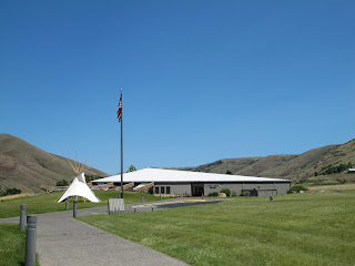

Nez Perce Nat'l Historic Park Visitor Center
To follow the actual route the Nez Perce took requires a four-wheel drive and, perhaps, a horse, but a passenger car will get you close enough to understand the human endurance required to make this journey. The fact that the route passes through some of the most scenic landscape in the West is an extra bonus. A good starting point is the Nez Perce National Historical Park Visitor Center on US 95, east of Lewiston, Idaho. Located on the site where Henry and Elizabeth Spalding established their Presbyterian mission, the center offers a video, display of Nez Perce artifacts, along with a selection of books and maps.

White Bird Overlook
Continuing on US 95, a slight detour south of Grangeville leads to the White Bird Battlefield overlook.  Interpretive signs tell the story of the first encounter between Howard’s army and Nez Perce warriors. At the end, 34 soldiers were killed.  While they suffered no casualties, Chief Joseph’s band of 750 people and 2,000 horses realized their best hope of safety was to travel east to Buffalo Country, and seek help from their allies, the Crow tribe.

U.S. 12 crosses North Central Idaho
Their journey followed the Lolo Trail over the Bitterroot Mountains in central Idaho, a route closely approximated today by US 12. Not completed until 1962, this winding, two-lane road follows the Clearwater and Lochsa Rivers through some of the most pristine, remaining wilderness areas. Known as the Northwest Passage Scenic Byway, It parallels the route used by Lewis and Clark and ends at Lolo Pass on the Montana border.


Bitterroot Valley, Western Montana
When the Nez Perce arrived here they falsely assumed they had left the war and pursuing army behind them, and turned south following the Bitterroot Valley. US 93 is the primary route through this lovely valley today, but this busy stretch of road can be avoided by traveling on parallel highway 269.  Not only is the scenery better, but the road passes through the small towns of Stevensville with its old Catholic mission, and Hamilton where you can tour the 25-room mansion of Copper King, Marcus Daly.

Big Hole National Battlefield Site
At the end of the valley, the route crosses the Continental Divide into the Big Hole. By this time, the Nez Perce were feeling comfortable enough to stop for some much needed rest. They set up their teepees along the banks of a stream and settled in. Before dawn on August 9, Colonel Gibbons and the 7th Infantry fired on the unsuspecting, sleeping village and the Big Hole Battle began. By the end of the carnage, both sides had sustained large losses. After burying their dead, the Nez Perce quickened their retreat across southwestern Montana, headed toward Yellowstone Park.

The road to Bannock Pass
A visitor center at the Big Hole National Battlefield Site offers a broad view of the valley where the fighting took place and an excellent video describing events. Beyond here, the road over Bannock Pass and eastward across Idaho is gravel, but well-graded and easy except for the occasional recalcitrant cow.

At Yellowstone, the army established traps at every exit to the east, but, once again, the Nez Perce managed to evade them. However, it soon became apparent that the Crow would be of no assistance and their only remaining hope was to travel north to asylum in Canada. By then, this ragtag band, now largely women, children and the elderly, had covered over a thousand miles and were exhausted.  Pausing at the Bear Paw Mountains, they were overtaken by the army and after a six-day siege, Chief Joseph surrendered his band, only 40 miles from the Canadian border. A monument marks the lonely, windswept spot.

Saturday, April 14, 2012

Rattlesnake Grade: A Road to Remember

Oregon Highway 3 on its descent to the Grande Ronde River
On the map, Oregon Highway 3 and its continuation, Washington Highway 129, appear to be a direct shot across the upper right-hand corner of the state, connecting Enterprise, Ore. and Clarkston, Wash.  However, the reality of this road is quite different. Why else would the American Motorcycle Association designate it as one of the top 15 motorcycle rides in America? The 80-mile trip offers an enormous variety of scenery from snow-capped peaks, expansive canyons, pine forests, wide open wheat fields, a narrow river valley, ghost town, and enough twists and turns and plunging drop-offs to make a person dizzy. Fortunately, there is very little traffic.

Joseph Canyon Overlook
Traveling from south to north, the drive begins in Enterprise, the county seat of Wallowa County and, more important, home to the last gas stations for the next 65 miles. The road heads north through rolling prairie and ranch land with spectacular views of the Wallowa Mountains receding in the rearview mirror. Elevation gain transforms the scenery to pine forests, and around 30 miles from Enterprise is the Joseph Canyon Overlook. From here, the view spreads out forever across a network of steep canyons. The Nez Perce called the area Saqanma, meaning long, rough canyon, and made their winter camp here at the confluence of Joseph Creek and the Grande Ronde River in the protected canyon’s bottom.

To savor this remarkable panorama, continue a few miles north to the Rim Rock Inn, a restaurant offering indoor and outdoor dining with a million dollar view. Who would expect to find a turkey panini sandwich with sun-dried tomatoes here in the absolute middle of nowhere! A former stagecoach stop, the inn now has four tepees available for rent for adventurous types wanting to spend the night right on the canyon edge.
Flora Methodist Church

Beyond the inn is a road turning west marked “Flora” and well worth the six mile, roundtrip detour to this once thriving farming and ranch community.  Platted in 1897, the town was named for the daughter of the first postmaster and grew to a population of 320 by 1910 with a bank, general store, and newspaper. The Methodist Episcopal Church was constructed in 1898 and an impressive, 8-room school house added to serve the rural community in 1915. However, the area’s isolation and the economic realities of the family farm contributed to the town’s demise and by 1966 the post office closed, followed by the school in 1977.  Today, the town (population 7) consists of a dozen or so abandoned houses and buildings, an overgrown cemetery, and an endless supply of photo opportunities. The church and school with its striking bell tower stand next to each other on the north side of town, dominating the landscape. The school has recently been restored with the idea of converting it to a center for pioneer arts and crafts.

Flora School
Back on Oregon 3, just beyond Buford Ridge Road, look for a pull-off on the left side of the road.  Here is the first, and probably the best, glimpse of the road ahead and explains why it is so popular with motorcyclists. Layer after layer of barren canyon opens up exposing the highway as it snakes its way down to the Grande Ronde River. About half way down, a sign proclaims, Welcome to Washington, The Evergreen State. Of course, in the late summer and early fall the scenery is shades of brown without a tree in sight. At the bridge over the river is a welcome token of civilization, Boggan’s Oasis.  Along the banks of the river, it promises the world’s best milk shakes, tasty burgers, overnight cabins, good fishing, and a swimming hole. It’s an excellent place to freshen up before tackling the next challenge, the ten mile, twisty ascent to the top of Rattlesnake Pass. This is a workout for a car and it seems almost unbelievable that several thousand participants in the 2010 Cycle Oregon tour made this trek on bicycles!

Beyond the pass, the route opens up into a broad plateau, skirts the small farming community of Anatone before one last thrilling corkscrew descent into the town of Asotin on the banks of the mighty Snake River. If the drive was not sufficiently thrilling, consider continuing on across the river to Clarkston. Here, several outfitters offer trips down the scenic Snake River through Hell’s Canyon, the deepest gorge in North America. A smorgasbord of options including full day trips, half days, overnight stays deep in the canyon, and wine and dinner cruises. 

More photos:


Boggan's Oasis, a popular stop for cyclists
 

Tuesday, January 10, 2012

Zumwalt Prairie: High, Wide, and Lonesome

Zumwalt Prairie
Vast grasslands once covered much of northeastern Oregon, eastern Washington, western Idaho and on up into Canada until homesteaders plowed these under to create the great wealth of wheat, potatoes, lentils that make this region famous. However, there was a section in Oregon that was a bit too high in elevation (between 3300’ and 5000’) and a bit too remote for farming to be successful.

Young, red-tailed hawk.
The Zumwalt Prairie, located north and east of the town of Enterprise in Wallowa County, is the largest (about 200 square miles) tract of remaining bunchgrass prairie in North America. Its rolling hills run from bright green in the spring and early summer to shades of yellow and brown as the season progresses. With little sign of human habitation other than a few cattle ranches and plenty of abandoned farmsteads, the place is alive with wildlife including 3,000 elk, black bears, wolves, cougars, bighorn sheep and over 48 varieties of butterflies. The prairie is home to one of North America’s highest concentrations of breeding raptors (golden eagles, prairie falcons, northern harriers, kestrels and numerous varieties of hawks) as well as grassland songbirds.

In 2000 and 2006, The Nature Conservancy purchased 33,000 acres, or about 51 square miles, and has been working in partnership with various state agencies and local ranchers to manage invasive species, develop sustainable grazing practices, and protect animal and plant habitats.
Abandoned farm on Zumwalt Prairie


To visit the prairie, fill up your gas tank and follow Hwy. 82 east of Enterprise about three miles. Turn onto Crow Creek Rd. to Zumwalt Rd. and follow the signs to Buckhorn Overlook. The road soon becomes gravel, but is well graded and fine for most passenger cars. Be sure to stop and look back at the sweeping view of the snow-capped Wallow Mountains. There are a few trailheads off Zumwalt and Duckett Roads, and a trail map produced by The Nature Conservancy is available at the Forest Service center in the town of Joseph.

View from Buckhorn Overlook
Other than the beauty, quiet, and wildlife, the main attraction in the prairie is the Buckhorn Overlook. Located at 5200’, this abandoned fire lookout sits on the edge of the Imnaha River Canyon and offers a view that is nothing short of spectacular. The steep walls of the Cow, Horse, and Lightning Creeks lead into the Imnaha River Canyon and beyond that is Hell’s Canyon (deeper than the Grand Canyon), and beyond that the peaks of the Seven Devils in Idaho. And, the best part of savoring the view is that you will probably have it all to yourself.

Sunday, April 18, 2010

When Bridges Covered Oregon

Bridges, so the saying goes, are America’s cathedrals. They inspire a range of emotions from awe to pride, but no bridge generates more affection than the humble, country, covered bridge. While most of these bridges are concentrated in the eastern states of New England, Pennsylvania and Ohio, Oregon can claim the number five spot and proudly boast of having the largest collection of covered bridges west of the Mississippi. Oregon’s tradition of bridge building dates back to 1851, when the first one was constructed in Oregon City. With the state’s vast forests of Douglas fir, wood was the obvious and logical building material, but not necessarily the best. A wooden plank bridge deck might last about eight or nine years before succumbing to the damp Northwest climate. On the other hand, one covered in a house frame to protect the deck and large timber trusses from the elements, could survive ten times longer. Soon covered bridges dotted the countryside, particularly in the Willamette Valley and southern timber counties. By the early part of the 1900s, the state was home to over 450 covered bridges.
Over time, however, new construction materials like steel, iron, and concrete made the wood bridges obsolete. The cost of maintaining these structures grew so dramatically that county and state highway departments chose to replace them with concrete spans. Many were dismantled and destroyed. Today, only 50 bridges remain in the state, largely through the efforts of local historical groups and the Oregon state legislature which provided funding for their preservation.
A good place to view a variety of these remaining links to the past is the small town of Scio, about 25 miles southeast of Salem in Linn County. Scio bills itself as “The Covered Bridge Capital of the West” and has five bridges within a ten mile radius, most of them spanning Thomas Creek The most colorful of the lot is the Shimanek Bridge, painted bright red with a white trim on its Gothic-style, louvered windows. Built in 1966, it is the area’s newest bridge replacing four earlier ones destroyed in floods and storms.
Downstream, on the other side of Scio, is the Gilkey Bridge, dating back to 1936. Recently, the bridge experienced a run of bad luck. In 1997, an over-loaded vehicle stressed the bridge creating serious damage and forcing its closure for a year of extensive repairs. In 2008, a large, farm service truck smashed into the bridge causing damage to the roof and side-support timbers. Once again, the bridge had to be closed for repairs but is back in business now.

The bridge offering the most attractive setting is the Larwood Bridge in a county wayside park of the same name. Here the Roaring River flows into Crabtree Creek, creating a geographical phenomenon so unusual, i.e. river flows into creek, it made it into Ripley’s Believe It Or Not. A pleasant, shaded picnic area offers a fine view of the bridge, streams, and the remnants of an old water-powered mill.

The Hannah Bridge, also dating to 1936 and spanning Thomas Creek, has open walls and exposed beams, making it one of the most attractive. Finally, the Hoffman Bridge over Crabtree Creek was built mostly with hand tools and adz marks are still visible in the upper timbers.

To learn more about the area’s covered bridges, a visit to the Depot Museum (open weekends only) in Scio is a must. Located in the old train depot from West Scio, the museum houses a collection of historical items from local pioneer families and has a notebook of clippings and early photos of area bridges that have been destroyed or replaced. A brochure is available detailing a bicycle and driving tour that visits all the local bridges.