One of the most tragic
events in American history began with the definition of the word, home. To the settlers of the newly-opened West, it
meant a permanent house with a barn on a piece of tillable land. To the Nez
Perce tribe, or Nimiipuu, “home” encompassed a wide swath of northeastern
Oregon, southwestern Washington, and central Idaho. A nomadic tribe, their
ancestors had lived here for generations following their seasonal food sources
of camas root, salmon, and game. From their first encounter with white men, the
Lewis and Clark expedition, the Nez Perce lived in harmony with their new
neighbors. However, a revised reservation boundary drawn up in 1863 forced the
tribe into 700,000 acres near Lapwai, Idaho. A number of Nez Perce, including
Chief Joseph’s Wallowa band, refused to sign and relinquish their “home;” they
became known as “non-treaty” Indians. Relations grew tense and in 1877, the
U.S. Army, under the command of General O.O. Howard, was ordered to remove the
non-treaties to the Lapwai reservation, triggering a 1,100-mile pursuit across Oregon,
Idaho, Montana, and Wyoming.
 |
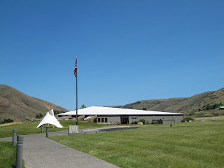
| Nez Perce Nat'l Historic Park Visitor Center |
To follow the actual route
the Nez Perce took requires a four-wheel drive and, perhaps, a horse, but a
passenger car will get you close enough to understand the human endurance
required to make this journey. The fact that the route passes through some of
the most scenic landscape in the West is an extra bonus. A good starting point
is the Nez Perce National Historical Park Visitor Center on US 95, east of
Lewiston, Idaho. Located on the site where Henry and Elizabeth Spalding
established their Presbyterian mission, the center offers a video, display of
Nez Perce artifacts, along with a selection of books and maps.
 |
| White Bird Overlook |
Continuing on US 95, a
slight detour south of Grangeville leads to the White Bird Battlefield
overlook. Interpretive signs tell the
story of the first encounter between Howard’s army and Nez Perce warriors. At
the end, 34 soldiers were killed. While
they suffered no casualties, Chief Joseph’s band of 750 people and 2,000 horses
realized their best hope of safety was to travel east to Buffalo Country, and
seek help from their allies, the Crow tribe.
 |
| U.S. 12 crosses North Central Idaho |
Their journey followed the
Lolo Trail over the Bitterroot Mountains in central Idaho, a route closely
approximated today by US 12. Not completed until 1962, this winding, two-lane
road follows the Clearwater and Lochsa Rivers through some of the most pristine,
remaining wilderness areas. Known as the Northwest Passage Scenic Byway, It
parallels the route used by Lewis and Clark and ends at Lolo Pass on the
Montana border.
 |
| Bitterroot Valley, Western Montana |
When the Nez Perce arrived
here they falsely assumed they had left the war and pursuing army behind them,
and turned south following the Bitterroot Valley. US 93 is the primary route
through this lovely valley today, but this busy stretch of road can be avoided
by traveling on parallel highway 269.
Not only is the scenery better, but the road passes through the small
towns of Stevensville with its old Catholic mission, and Hamilton where you can
tour the 25-room mansion of Copper King, Marcus Daly.
 |
| Big Hole National Battlefield Site |
At the end of the valley,
the route crosses the Continental Divide into the Big Hole. By this time, the
Nez Perce were feeling comfortable enough to stop for some much needed rest.
They set up their teepees along the banks of a stream and settled in. Before
dawn on August 9, Colonel Gibbons and the 7th Infantry fired on the unsuspecting,
sleeping village and the Big Hole Battle began. By the end of the carnage, both
sides had sustained large losses. After burying their dead, the Nez Perce
quickened their retreat across southwestern Montana, headed toward Yellowstone
Park.
 |
| The road to Bannock Pass |
A visitor center at the
Big Hole National Battlefield Site offers a broad view of the valley where the
fighting took place and an excellent video describing events. Beyond here, the
road over Bannock Pass and eastward across Idaho is gravel, but well-graded and
easy except for the occasional recalcitrant cow.
At Yellowstone, the army
established traps at every exit to the east, but, once again, the Nez Perce
managed to evade them. However, it soon became apparent that the Crow would be
of no assistance and their only remaining hope was to travel north to asylum in
Canada. By then, this ragtag band, now largely women, children and the elderly,
had covered over a thousand miles and were exhausted. Pausing at the Bear Paw Mountains, they were
overtaken by the army and after a six-day siege, Chief Joseph surrendered his
band, only 40 miles from the Canadian border. A monument marks the lonely,
windswept spot.


Thanks for this excellent description, my wife and I are even travelling along their route. Fascinating American history.
ReplyDeleteMany thanks, Terry and Sally www.roadblog14fall.blogspot.com