Monday, March 18, 2013

Ghost Canneries of the Lower Columbia River


 It was much more than our childhood memories of those unsavory, school-lunch salmon patties served with creamed peas that brought down the salmon cannery business along the lower Columbia.  A combination of overfishing, degradation of spawning habitat upstream, and the construction of dams on the Columbia and its tributaries combined to destroy what had been in early history, salmon runs estimated as large as 16 million annually.

For centuries, natives fished the river, preserving the salmon through smoking or drying processes. Early Europeans tried salting and packing salmon in barrels which were shipped to Hawaii and the East Coast with mixed results. However, improvements in canning methods meant the fish could be packed safely and travel all over the world.  The Hume brothers opened the first salmon cannery in 1866 in Eagle Cliff, Washington, a few miles upstream from present day Cathlamet. Their success spawned the development of more canneries along the lower Columbia River, and by the heyday of the late 1880s, there were 38 canneries in the area, packing as much as 30 million, one-pound cans a year. That’s a lot of potential salmon patties.

Pier 39, Astoria
The canneries brought jobs to the area along with a rich mix of ethnic groups whose cultures and influence have remained.  In the early days, much of the dirty work of butchering salmon was done by Chinese men supplied by labor contractors out of San Francisco.  With the Chinese Exclusion Act of 1882, canneries turned to Filipinos and Japanese workers, while at the same time immigrants from Scandinavia, Finland, Yugoslavia and the Mediterranean arrived to fish and labor in the canneries.

Inside the Bumble Bee Museum
Astoria, Oregon, was the center of the canning business and carried the moniker, Cannery Capital of the World. Once home to 22 canneries, it’s a good place to begin a tour of what remains of this important industry.  Nearly all the wooden cannery buildings have succumbed to old age and blustery winter storms, but a few remain in Astoria. At the end of 39th St. on the eastern end of town is Pier 39, the old Hanthorn/Bumble Bee Cannery.  It was the last operating cannery in the area, closing in 1980. Today it houses a coffee shop, pub, and the free Bumble Bee museum. Inside are wooden gill-netter boats, old cannery processing equipment, and photos of the days when Bumble Bee was Astoria’s largest employer.

Big Red, Astoria
Nearby, at the end of 31st St., is a large, hulking, red building sitting out in the river and looking a bit tattered. Known as Big Red, it served as a satellite station for Union Fishermen’s Coop where fishermen could drop off their catch and spread their nets to dry. Over 100 years old, the wooden structure lost its top story in a wind storm in 2007, but efforts are underway to save this piece of history.

Cross the Astoria-Megler Bridge to the Washington side of the river and follow Hwy 401 east to Knappton Cove. Rotting wooden posts extending out into the water are all that remain of the Eureka and Epicure Packing Co. In 1899, the federal government built a quarantine station on the site of the abandoned cannery. Ships arriving in Astoria were inspected for any signs of contagious diseases. If infected, they were directed across the river to the quarantine station, or pest house.  Ships were fumigated with burning sulfur and passengers treated for disease. Today the building houses a museum open on Saturdays during summer months.
Knappton Cove Quarantine Station

Altoona, Washington
A bit further east, a winding road leads south from Rosburg to the ghost town of Altoona. A few houses and wooden pilings in the river are all that remain of a town that was once a major port for steamers traveling between Portland and Astoria. This stretch of the river had six canneries in the early 1900s, but today it is a quiet spot in a beautiful setting.  Large rock pillars topped with hemlocks sit in the harbor, and the end-of-the-road atmosphere makes it well worth the 13-mile, round-trip detour.

In the town of Cathlamet along the riverfront, a little upstream from the boarded-up Water Rat Tap Tavern, is what remains of the Warren Cannery. Two years ago, a large part of the building collapsed and today what little remains is being salvaged. Once gone, it will join its fellow ghost canneries along the lower Columbia.
Remnants of the Warren Cannery, Cathlamet

Saturday, March 16, 2013

Following the Flight of the Nez Perce


One of the most tragic events in American history began with the definition of the word, home.  To the settlers of the newly-opened West, it meant a permanent house with a barn on a piece of tillable land. To the Nez Perce tribe, or Nimiipuu, “home” encompassed a wide swath of northeastern Oregon, southwestern Washington, and central Idaho. A nomadic tribe, their ancestors had lived here for generations following their seasonal food sources of camas root, salmon, and game. From their first encounter with white men, the Lewis and Clark expedition, the Nez Perce lived in harmony with their new neighbors. However, a revised reservation boundary drawn up in 1863 forced the tribe into 700,000 acres near Lapwai, Idaho. A number of Nez Perce, including Chief Joseph’s Wallowa band, refused to sign and relinquish their “home;” they became known as “non-treaty” Indians. Relations grew tense and in 1877, the U.S. Army, under the command of General O.O. Howard, was ordered to remove the non-treaties to the Lapwai reservation, triggering a 1,100-mile pursuit across Oregon, Idaho, Montana, and Wyoming.


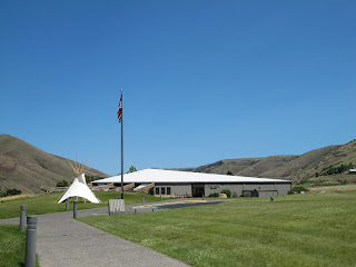
Nez Perce Nat'l Historic Park Visitor Center
To follow the actual route the Nez Perce took requires a four-wheel drive and, perhaps, a horse, but a passenger car will get you close enough to understand the human endurance required to make this journey. The fact that the route passes through some of the most scenic landscape in the West is an extra bonus. A good starting point is the Nez Perce National Historical Park Visitor Center on US 95, east of Lewiston, Idaho. Located on the site where Henry and Elizabeth Spalding established their Presbyterian mission, the center offers a video, display of Nez Perce artifacts, along with a selection of books and maps.

White Bird Overlook
Continuing on US 95, a slight detour south of Grangeville leads to the White Bird Battlefield overlook.  Interpretive signs tell the story of the first encounter between Howard’s army and Nez Perce warriors. At the end, 34 soldiers were killed.  While they suffered no casualties, Chief Joseph’s band of 750 people and 2,000 horses realized their best hope of safety was to travel east to Buffalo Country, and seek help from their allies, the Crow tribe.

U.S. 12 crosses North Central Idaho
Their journey followed the Lolo Trail over the Bitterroot Mountains in central Idaho, a route closely approximated today by US 12. Not completed until 1962, this winding, two-lane road follows the Clearwater and Lochsa Rivers through some of the most pristine, remaining wilderness areas. Known as the Northwest Passage Scenic Byway, It parallels the route used by Lewis and Clark and ends at Lolo Pass on the Montana border.


Bitterroot Valley, Western Montana
When the Nez Perce arrived here they falsely assumed they had left the war and pursuing army behind them, and turned south following the Bitterroot Valley. US 93 is the primary route through this lovely valley today, but this busy stretch of road can be avoided by traveling on parallel highway 269.  Not only is the scenery better, but the road passes through the small towns of Stevensville with its old Catholic mission, and Hamilton where you can tour the 25-room mansion of Copper King, Marcus Daly.

Big Hole National Battlefield Site
At the end of the valley, the route crosses the Continental Divide into the Big Hole. By this time, the Nez Perce were feeling comfortable enough to stop for some much needed rest. They set up their teepees along the banks of a stream and settled in. Before dawn on August 9, Colonel Gibbons and the 7th Infantry fired on the unsuspecting, sleeping village and the Big Hole Battle began. By the end of the carnage, both sides had sustained large losses. After burying their dead, the Nez Perce quickened their retreat across southwestern Montana, headed toward Yellowstone Park.

The road to Bannock Pass
A visitor center at the Big Hole National Battlefield Site offers a broad view of the valley where the fighting took place and an excellent video describing events. Beyond here, the road over Bannock Pass and eastward across Idaho is gravel, but well-graded and easy except for the occasional recalcitrant cow.

At Yellowstone, the army established traps at every exit to the east, but, once again, the Nez Perce managed to evade them. However, it soon became apparent that the Crow would be of no assistance and their only remaining hope was to travel north to asylum in Canada. By then, this ragtag band, now largely women, children and the elderly, had covered over a thousand miles and were exhausted.  Pausing at the Bear Paw Mountains, they were overtaken by the army and after a six-day siege, Chief Joseph surrendered his band, only 40 miles from the Canadian border. A monument marks the lonely, windswept spot.