Tuesday, October 29, 2013

Shore Acres Park, a Seasonal Delight


What an amazing Christmas present Cassie Simpson received in 1906! Her husband, lumber baron and shipping tycoon Louis J. Simpson, gifted her with a splendid mansion on a high promontory overlooking the Pacific Ocean near Cape Arago on the southern Oregon Coast. It must have been a challenge to wrap with its heated indoor pool, huge stone fireplace, myrtlewood wall paneling, and 2700-square foot ballroom.

What began as a summer home eventually became their fulltime residence as art work, riding stables, tennis courts, and a Roman bath were added to the property. Louis had a strong interest in developing a formal garden. The rich soil and coastal, temperate climate created perfect growing conditions, and soon hydrangeas and roses were supplemented with exotic plants from around the world delivered via his ships.

Sadly, Cassie died in 1921 and later that year the entire house burned to the ground. Six years later, an even grander replacement mansion was constructed on the site, but the realities of the approaching financial Depression of the 1930s drained Simpson’s resources. The house was never completed and gradually fell into disrepair. The property was sold to the state of Oregon in 1942 and, during World War II, was used as a barracks for soldiers.

After the war, the house was torn down but the formal garden, gardener’s cottage, and spectacular view remained to become Shore Acres State Park. The park, located 13 miles south of Coos Bay/North Bend, occupies a three-mile stretch of coastline between Sunset Bay and Cape Arago. On the site where the Simpsons’ mansion once stood is a glass-enclosed observation building. This is a great spot for viewing wild, winter waves and migrating whales while staying dry and out of the wind.

Trails to the north and south offer more dramatic views of the surf and tilted layers of exposed rock where wave erosion has created unusual holes and knobs on the sandstone cliffs. Slightly south of the park, a new interpretive overlook offers views to Shell Island and Simpson Reef. Noisy, barking seals, sea lions, and elephant seals can be seen year-round, and gray whales travel along the coast here from December to June.

Competing with this rugged seascape is a remarkable seven-acre botanical garden.  Carefully manicured and maintained, it offers a long season of blooms starting with spring bulbs and tulips (over 8,000), azaleas, and rhododendrons.  Later, roses and other perennials and annuals provide summer color while dahlias take center stage in the early fall. There is also a Japanese-style garden with a lily pond guarded by a pair of bronze herons, and a 95-foot tall Monterey pine dating back to the original estate. An extensive gift shop at the garden’s entrance offers many gardening related items and crafts made by local artisans.

Beginning in 1987, the non-profit Friends of Shore Acres started an annual Christmas tradition of decorating the garden with lights. Today it takes 1500 volunteers to string 300,000 lights around trees and shrubs and 26 holiday trees. Large sculptures shaped by lights include a whale, jellyfish, frog, Dungeness crab, butterflies, and even underwater koi fish in the lily pond. Refreshments and musical entertainment complete the holiday experience. Last year this community event drew 47,000 visitors from 28 countries and 45 states to this remote section of the Oregon Coast. This year’s display will begin November 28 and run through December 31.

Monday, September 30, 2013

Little Walks Near a Big Mountain


At 11,239-feet, Mt. Hood is Oregon’s tallest peak and sits like a snowy sentinel guarding the state. It is the most climbed glaciated mountain peak in the country with nearly 10,000 people attempting its summit every year. If it has been your lifelong dream to climb Mount Hood, but sitting around
Mt. Hood from Timberline Lodge
the fireplace at Timberline Lodge is more your speed, you’ll be pleased to learn there are some wonderful, easy walks with big rewards in the area. 


Highway 26 is the most convenient route to reach Mt. Hood from Portland and roughly parallels the old Barlow Road built in 1845 as an alternative for Oregon Trail travelers wanting to avoid the treacherous Columbia River. The first easy walk is on the south side of the highway between mileposts 39 and 40 at the Wildwood Recreation Site. Managed by the Bureau of Land Management, the paved Cascade Streamwatch 
Underwater Viewing Window
Trail is a flat, ¾-mile loop through a pretty forest along the Salmon River. The highlight is an underwater viewing window where you can observe life in a moving stream. If you want a longer walk, add on the Wetland Trail beginning in the same parking lot.

Next stop, a few miles away, is the Zigzag Ranger Station where you can pick up maps of the Mt. Hood National Forest as well as informational sheets on most of these trails. Before leaving the ranger station, walk behind the visitor center to admire the complex of structures built during the Depression by the Civilian Conservation Corps. They are also responsible for many of the trails, bridges, and campgrounds in the area.

About six miles east of the station, look for a sign on the left for Camp Kiwanis Road and follow it a short distance until it ends at the trailhead for Little Zigzag Falls.
Zigzag Falls
Note the 1920-era bridge from the old Mt. Hood Loop Highway before following the trail into the forest. The walk parallels the rushing Little Zigzag River for about one-half mile, ending at a spectacular waterfall.

Back on Hwy. 26, between mileposts 50 and 51, watch for a large, historical marker which is the beginning of the Laurel Hill Chute Trail. A series of gentle switchbacks leads up to a view point of this infamous stretch of the Barlow Road.  The descent was so steep wagons and oxen had to be lowered by a system of winches and ropes; the road was described as “rough to barely passable.”

A few miles east of Government Camp, look for a sign on the south side for Trillium Lake. This much-photographed jewel offers a mirror reflection of Mt. Hood on sunny days. An easy two-mile trail encircles the lake and is popular in the winter with snowshoers and cross-country skiers.


Trillium Lake
Continuing east on Highway 26, you will find two more scenic lakes located off Skyline Road. The first, Little Crater Lake, is much smaller than its namesake, only 100-feet across, but quite unusual.  Dissolving limestone and artesian spring waters have created a lake 45-feet deep, and an
Little Crater Lake
astonishing, sapphire blue. The spring-fed water remains at 32 degrees year round.

Nearby Timothy Lake is the largest lake in the region and offers camping, fishing, and boating. The Lakeshore Trail encircles the lake for 13 miles, but a short walk, especially from the Hoodview Campground, will provide another good vista of Mt. Hood in the distance.

And, finally, there’s that fireplace at Timberline Lodge, off Highway 26 beyond Government Camp. Behind the lodge, a crisscross of trails follow around the mountain’s base and to higher levels, but you can follow short sections of longer trails to soak up the alpine setting and great close-up views of the mountain.

To learn more about these walks and longer ones visit the Mt. Hood National Forest website at www.fs.usda.gov/mt hood; click on Go Hiking, then Day Hiking.  Some of the trailheads in the forest require a National Forest Day Pass ($5) which is available at the Zigzag station. If you are over 62 and have already acquired your Senior Pass, you can use that. If you do not have your Senior Pass, you can buy one there by showing proof of age. The pass is valid in National Forests, National Parks, BLM sites, and lasts your lifetime. For $10, it’s the best bargain in the world.

Saturday, August 10, 2013

Cascade Locks


Cascade Locks and Bridge of the Gods
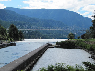
In the final chapter of her bestselling book, Wild, author Cheryl Strayed ponders her experiences on the Pacific Crest Trail while enjoying a soft serve cone at the Eastwind Drive-In at Cascade Locks, Ore. Located 40 miles east of Portland off Interstate 84, it’s the only town on the trail’s 2600-mile journey from the Mexican border to Canada, and the spot where the trail crosses the mighty Columbia River via the Bridge of the Gods.
The town, one of the oldest in Oregon, has long been a place where travelers needed to come to terms with their plans. An ancient landslide created a series of whitewater rapids and cascades that served as a major barrier in the river, forcing a long portage around them.  Lewis and Clark described the cascades as “…water passing with great velocity forming and boiling in a horrible manner…”,  and pioneers on the Oregon Trail had to choose between the hard trek over the Barlow Road, or facing the rapids in a make-shift raft with the possibility of losing everything.
 

In 1856, a portage road was built and mules carried freight around the cascades until they were replaced with the Oregon Pony, the first steam locomotive to operate west of the Mississippi. The Pony, described as an “ungainly contraption,” with its tiny engine carried around 200 tons of freight each day. Passengers rode in one small coach or aboard the flatcars.

Historical Museum
The era of portage railroad ended in 1897 when the U.S. Army Corps of Engineers completed a series of locks to move river traffic around the cascades. Later, when the Bonneville Dam and Locks were completed during the New Deal, the waters flooded the old locks leaving only skeletal stone and concrete outlines, and stairs leading to nowhere.  What remains is now a National Historic Site and can be viewed at the town’s Marina Park, owned and operated by the Port of Cascade Locks. This attractive, riverside swatch of parkland is also home to the Oregon Pony which currently resides in its own glass-enclosed and climate-controlled structure.  Next to it, occupying the former lock tender’s house, is the Cascade Locks Historical Museum with three floors of artifacts and mementos from the region’s past.  

At the east end of the park are statues of Lewis and Clark guide, Sacagawea, and their canine traveling companion, Seaman. Next door at the Locks Waterfront Café is the docking site of the Columbia Gorge Sternwheeler, a three-story replica of the ships that cruised the Gorge in the 1800s. Built in 1983 in Hood River, this 499-passenger paddle
Columbia Gorge Sternwheeler
wheeler offers narrated excursions, brunch and dinner cruises on the river between May and October.

A few miles downstream is an attraction well worth a short detour off Interstate 84.  While a working fish hatchery might not be on anyone’s top ten sightseeing list, the Bonneville Hatchery is located in a pretty, creek side setting with stone ponds, flowers, tall trees, and neatly manicured grounds, and receives over a million visitors annually.  The hatchery, opened in 1909, raises fall Chinook salmon, Coho salmon, and summer and winter steelhead. A self-guided tour leads visitors through the process. In the historic, wooden Egg Incubation Building, a small museum covers everything anyone would want to know about salmon and their fascinating life cycle. However, the biggest and best known attraction at the hatchery is Herman, a 70-year-old, 450 pounds, ten foot
Egg Incubation Building and Museum
long sturgeon. He and his buddies can be observed through an underwater, glass window. The adjacent Bonneville Dam and Locks also welcomes visitors.

Cascade Locks is the nearest town to a number of popular Columbia Gorge hiking trails.  In addition to the Pacific Coast Trail, there is access nearby to the Eagle Creek and Wahclella Falls trails offering some of the Gorge’s most spectacular scenery and waterfalls. This spring, a new mountain bike trail opened on the east side of town.
Herman


Saturday, June 22, 2013

Bandon-by-the-Sea


When Irish immigrant George Bennett arrived at the mouth of the Coquille River on the southern Oregon Coast he brought the name of his Irish hometown, Bandon, to the new settlement.  Additionally, he brought an Irish shrub called gorse (ulex europaeus) and planted it as a fence hedge surrounding his property.
Gorse is plentiful along Oregon's South Coast
This ornamental evergreen with its bright yellow blossoms soon infested the area, spreading along the sand dunes and throughout the town. Unfortunately, the high oil content of its foliage made the plant extremely flammable, a factor that would change Bandon forever.

In 1936, the town was a thriving community: a logging and fishing center, home to cows and cranberries, and the busiest port between San Francisco and Portland. On a warm and dry September evening, a shift in winds brought a nearby forest fire closer to town. When it reached the gorse, the fire exploded into an inferno completely destroying the entire commercial district in a short time and leaving 1800 inhabitants homeless.

Coquille River Lighthouse
Like the mythological Phoenix, the town rose from the ashes and rebuilt itself. Today, Bandon-by-the-Sea, as it is known in tourism parlance, is a favorite destination on the Oregon Coast. The Bandon Dunes Golf Resort, a complex of five courses just north of town, attracts players from all over the world. Set on a bluff overlooking the ocean and dunes, it consistently appears on any list of top ten golf courses and compares favorably to some of the best in Scotland and Ireland.

There is more than golf to keep visitors coming back. Like any coastal community, the ocean is the big draw, and the setting in Bandon couldn’t be more spectacular. Wide, sandy beaches are easily accessible and offer a plethora of driftwood, agates, jasper, and petrified wood. Offshore are wildly sculpted sea stacks and monolithic rock formations providing sanctuary for a wide variety of sea birds. Where the Coquille River meets the ocean, an octagonal lighthouse with a tall round tower stands guard over the perilous bar. Built in 1896, it was the last lighthouse constructed along the Oregon Coast. It was decommissioned in 1939, but volunteers and lighthouse enthusiasts keep this landmark maintained and opened to the public during summer months.

Wooden, welcome arches lure travelers along Highway 101 to detour into Bandon’s Old Town. This compact downtown offers a variety of shops, galleries, restaurants, an excellent history museum, independent bookstore, and plenty of free parking. A walkable waterfront lines one of the two main streets allowing close access to fishing boats, charters, and fresh seafood. Bandon Fish
Market makes a tasty stop for fish and chips followed by a dessert visit to Cranberry Sweets located across the street. This local institution features all sorts of cranberry candy goodies, and they are most generous with their free samples.

Cranberries are an important business here and Bandon boasts of being “The Cranberry Capital of Oregon.” The acidic, sandy soil and mild climate make it a perfect place for cranberries and there are nearly 1600 acres under cultivation. Bogs can be seen along Highway 101 north and south of town with most of these berries destined for bottles of Ocean Spray juice.  On the second full weekend in September, the town celebrates this crop with a four-day cranberry festival.

Bandon Fish Market
Bandon is also known for its dairy industry and for years, Bandon Cheese was a popular stop for visitors traveling the coast. After the business was sold to Tillamook Cheese, the creamery and retail store closed, but a new cheese factory opened this spring. Face Rock Creamery will be offering a variety of their locally made cheddars as well as squeaky cheese curds and Umpqua ice cream cones.

The town of Bandon is bookended by two state parks. To the north is Bullards Beach State Park with a large campground, sandy beach, and access to the lighthouse. To the south, is a string of state owned lands including Face Rock Scenic Viewpoint and Bandon Natural Area offering beach access and close-up viewing of the rock formations offshore. Beach Loop Road parallels the ocean, connecting all these scenic vistas. No trip to Bandon would be complete without a stop at 11th Avenue and Beach Loop Road at Coquille Point for a calendar view of the very best of the Oregon Coast.

From Coquille Point

Sunday, May 19, 2013

Memorial Day Monuments


For many, Memorial Day signals the beginning of summer, the kickoff of white shoe season, the Indy 500, Oregon winery open-house weekend, and yet another federal three-day holiday. However, it is important to reflect on the history and significance of this day that honors the men and women in the military services who have made the ultimate sacrifice for their country.
Soldier's Monument, Lone Fir Cemetery
Originally known as Decoration Day, the holiday’s beginnings are a little fuzzy depending on a Yankee or Confederate perspective. At the end of the Civil War, in May of 1868, Commander of the Grand Army of the Republic, General John Logan, officially proclaimed May 30 a day of commemoration, and flowers were placed on the graves of the 20,000 Union and Confederate soldiers buried in Arlington National Cemetery. Southern states refused to follow the May 30 tradition and had their own Confederate Memorial Days. By the end of World War I, the observance was expanded to include fallen soldiers of all wars and in 1971, it became officially known as Memorial Day and observed on the last Monday in the month of May.
The Portland area features a number of war and veteran memorials, many of them tucked out of the way, others in public areas but largely ignored. The oldest monument honoring the war dead is in Lone Fir Cemetery on 26th SE, between Stark and Morrison. The Soldier’s Monument, near the center of the cemetery, was dedicated in 1903 to the veterans of the Civil War, Mexican, Spanish, and Indian Wars and is typical of that era, a bronze soldier with flag standing on top a stone pediment. The cemetery, dating back to 1846, is final home to over 200 Civil War veterans.

Lownsdale Square, Portland
Another pedestal-soldier style monument is located in downtown Portland in Lownsdale Square at the intersection of SW 4th and Main. Unveiled in 1906, Soldiers Monument is dedicated to Oregonians killed in the Spanish American War. The tall, granite obelisk is topped by a bronze replica of an infantryman of the Second Oregon U.S. Volunteer Infantry. At the base of the statue are two Howitzers used at Fort Sumter at the start of the Civil War.  One points north; the other south.

Across the Willamette River, in the Rose Quarter, stands the Veterans Memorial Coliseum. This indoor arena with its unusual glass design was built in 1960 and dedicated in 1961 to the veterans of World Wars I and II. Two black, polished granite slabs inscribed with the names of the fallen sit at a lower level on either side of the main entrance.

Korean War Memorial, Wilsonville
Many veterans of these two wars are interred in the Willamette National Cemetery located east of I-205 (one of many Blue Star Memorial Highways in Oregon) on the flanks of Mt. Scott. The largest military cemetery east of the Mississippi, it covers over 300 acres and the beautiful, hillside setting provides panoramic views of Portland. Several Medal of Honor recipients as well as former Senator and Governor Mark Hatfield are buried here along with nearly 150,000 veterans and their family members. Korean War veterans are honored with a large granite monument listing the names of the 283 Oregonians lost in that conflict. South of Portland, in the city of Wilsonville is another memorial honoring Korean War vets. Located in the Town Center Park, the 94-foot long pink granite wall also lists those servicemen killed.

Vietnam Memorial, Washington Park
Probably the most striking of all Portland’s war memorials is the Vietnam Veterans of Oregon Memorial in Washington Park, between Hoyt Arboretum and the World Forestry Center. Set in a verdant bowl surrounded by tall trees, the monument was dedicated in 1987 to the more than 700 men and women who died or remain missing in action in that conflict. A spiral path follows the contour of the bowl and is lined with several curved granite walls representing the years between 1959 and 1976. The names of those lost are engraved on the stone along with information about the history of the war during that time period and news from the home front here in Oregon. The “news” runs the gamut from the notable to the nonsensical and provides a provocative contrast to the war and the lost lives.

Vietnam Memorial, Washington Park
While flipping your burgers and grilling your hot dogs this Memorial Day, take just a moment to remember that freedom is never free; or, better yet, take a bouquet of flowers to one of these monuments

Monday, March 18, 2013

Ghost Canneries of the Lower Columbia River


 It was much more than our childhood memories of those unsavory, school-lunch salmon patties served with creamed peas that brought down the salmon cannery business along the lower Columbia.  A combination of overfishing, degradation of spawning habitat upstream, and the construction of dams on the Columbia and its tributaries combined to destroy what had been in early history, salmon runs estimated as large as 16 million annually.

For centuries, natives fished the river, preserving the salmon through smoking or drying processes. Early Europeans tried salting and packing salmon in barrels which were shipped to Hawaii and the East Coast with mixed results. However, improvements in canning methods meant the fish could be packed safely and travel all over the world.  The Hume brothers opened the first salmon cannery in 1866 in Eagle Cliff, Washington, a few miles upstream from present day Cathlamet. Their success spawned the development of more canneries along the lower Columbia River, and by the heyday of the late 1880s, there were 38 canneries in the area, packing as much as 30 million, one-pound cans a year. That’s a lot of potential salmon patties.

Pier 39, Astoria
The canneries brought jobs to the area along with a rich mix of ethnic groups whose cultures and influence have remained.  In the early days, much of the dirty work of butchering salmon was done by Chinese men supplied by labor contractors out of San Francisco.  With the Chinese Exclusion Act of 1882, canneries turned to Filipinos and Japanese workers, while at the same time immigrants from Scandinavia, Finland, Yugoslavia and the Mediterranean arrived to fish and labor in the canneries.

Inside the Bumble Bee Museum
Astoria, Oregon, was the center of the canning business and carried the moniker, Cannery Capital of the World. Once home to 22 canneries, it’s a good place to begin a tour of what remains of this important industry.  Nearly all the wooden cannery buildings have succumbed to old age and blustery winter storms, but a few remain in Astoria. At the end of 39th St. on the eastern end of town is Pier 39, the old Hanthorn/Bumble Bee Cannery.  It was the last operating cannery in the area, closing in 1980. Today it houses a coffee shop, pub, and the free Bumble Bee museum. Inside are wooden gill-netter boats, old cannery processing equipment, and photos of the days when Bumble Bee was Astoria’s largest employer.

Big Red, Astoria
Nearby, at the end of 31st St., is a large, hulking, red building sitting out in the river and looking a bit tattered. Known as Big Red, it served as a satellite station for Union Fishermen’s Coop where fishermen could drop off their catch and spread their nets to dry. Over 100 years old, the wooden structure lost its top story in a wind storm in 2007, but efforts are underway to save this piece of history.

Cross the Astoria-Megler Bridge to the Washington side of the river and follow Hwy 401 east to Knappton Cove. Rotting wooden posts extending out into the water are all that remain of the Eureka and Epicure Packing Co. In 1899, the federal government built a quarantine station on the site of the abandoned cannery. Ships arriving in Astoria were inspected for any signs of contagious diseases. If infected, they were directed across the river to the quarantine station, or pest house.  Ships were fumigated with burning sulfur and passengers treated for disease. Today the building houses a museum open on Saturdays during summer months.
Knappton Cove Quarantine Station

Altoona, Washington
A bit further east, a winding road leads south from Rosburg to the ghost town of Altoona. A few houses and wooden pilings in the river are all that remain of a town that was once a major port for steamers traveling between Portland and Astoria. This stretch of the river had six canneries in the early 1900s, but today it is a quiet spot in a beautiful setting.  Large rock pillars topped with hemlocks sit in the harbor, and the end-of-the-road atmosphere makes it well worth the 13-mile, round-trip detour.

In the town of Cathlamet along the riverfront, a little upstream from the boarded-up Water Rat Tap Tavern, is what remains of the Warren Cannery. Two years ago, a large part of the building collapsed and today what little remains is being salvaged. Once gone, it will join its fellow ghost canneries along the lower Columbia.
Remnants of the Warren Cannery, Cathlamet

Saturday, March 16, 2013

Following the Flight of the Nez Perce


One of the most tragic events in American history began with the definition of the word, home.  To the settlers of the newly-opened West, it meant a permanent house with a barn on a piece of tillable land. To the Nez Perce tribe, or Nimiipuu, “home” encompassed a wide swath of northeastern Oregon, southwestern Washington, and central Idaho. A nomadic tribe, their ancestors had lived here for generations following their seasonal food sources of camas root, salmon, and game. From their first encounter with white men, the Lewis and Clark expedition, the Nez Perce lived in harmony with their new neighbors. However, a revised reservation boundary drawn up in 1863 forced the tribe into 700,000 acres near Lapwai, Idaho. A number of Nez Perce, including Chief Joseph’s Wallowa band, refused to sign and relinquish their “home;” they became known as “non-treaty” Indians. Relations grew tense and in 1877, the U.S. Army, under the command of General O.O. Howard, was ordered to remove the non-treaties to the Lapwai reservation, triggering a 1,100-mile pursuit across Oregon, Idaho, Montana, and Wyoming.


Nez Perce Nat'l Historic Park Visitor Center
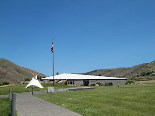
To follow the actual route the Nez Perce took requires a four-wheel drive and, perhaps, a horse, but a passenger car will get you close enough to understand the human endurance required to make this journey. The fact that the route passes through some of the most scenic landscape in the West is an extra bonus. A good starting point is the Nez Perce National Historical Park Visitor Center on US 95, east of Lewiston, Idaho. Located on the site where Henry and Elizabeth Spalding established their Presbyterian mission, the center offers a video, display of Nez Perce artifacts, along with a selection of books and maps.

White Bird Overlook
Continuing on US 95, a slight detour south of Grangeville leads to the White Bird Battlefield overlook.  Interpretive signs tell the story of the first encounter between Howard’s army and Nez Perce warriors. At the end, 34 soldiers were killed.  While they suffered no casualties, Chief Joseph’s band of 750 people and 2,000 horses realized their best hope of safety was to travel east to Buffalo Country, and seek help from their allies, the Crow tribe.

U.S. 12 crosses North Central Idaho
Their journey followed the Lolo Trail over the Bitterroot Mountains in central Idaho, a route closely approximated today by US 12. Not completed until 1962, this winding, two-lane road follows the Clearwater and Lochsa Rivers through some of the most pristine, remaining wilderness areas. Known as the Northwest Passage Scenic Byway, It parallels the route used by Lewis and Clark and ends at Lolo Pass on the Montana border.


Bitterroot Valley, Western Montana
When the Nez Perce arrived here they falsely assumed they had left the war and pursuing army behind them, and turned south following the Bitterroot Valley. US 93 is the primary route through this lovely valley today, but this busy stretch of road can be avoided by traveling on parallel highway 269.  Not only is the scenery better, but the road passes through the small towns of Stevensville with its old Catholic mission, and Hamilton where you can tour the 25-room mansion of Copper King, Marcus Daly.

Big Hole National Battlefield Site
At the end of the valley, the route crosses the Continental Divide into the Big Hole. By this time, the Nez Perce were feeling comfortable enough to stop for some much needed rest. They set up their teepees along the banks of a stream and settled in. Before dawn on August 9, Colonel Gibbons and the 7th Infantry fired on the unsuspecting, sleeping village and the Big Hole Battle began. By the end of the carnage, both sides had sustained large losses. After burying their dead, the Nez Perce quickened their retreat across southwestern Montana, headed toward Yellowstone Park.

The road to Bannock Pass
A visitor center at the Big Hole National Battlefield Site offers a broad view of the valley where the fighting took place and an excellent video describing events. Beyond here, the road over Bannock Pass and eastward across Idaho is gravel, but well-graded and easy except for the occasional recalcitrant cow.

At Yellowstone, the army established traps at every exit to the east, but, once again, the Nez Perce managed to evade them. However, it soon became apparent that the Crow would be of no assistance and their only remaining hope was to travel north to asylum in Canada. By then, this ragtag band, now largely women, children and the elderly, had covered over a thousand miles and were exhausted.  Pausing at the Bear Paw Mountains, they were overtaken by the army and after a six-day siege, Chief Joseph surrendered his band, only 40 miles from the Canadian border. A monument marks the lonely, windswept spot.